In this section we summarize some basic concepts that are used in the celestial navigation literature. Some concepts are specific to Earth, even though they could be adapted to other celestial bodies. An extensive treatment is given by Hobbs [7].
Basic facts are:
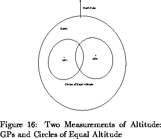
At any given time, a measurement of Sun altitude constrains the observer to be in a circle on the terrestrial surface. Such a circle is called circle of equal altitude. A circle of equal altitude is defined by a measurement of Sun altitude and knowledge of the GP of Sun. Two measurements of altitude are enough to constrain the observer to two points; three measurements are enough to constrain the observer to one point. More measurements of altitude overconstrain position and can be used to check or correct previous measurements. Figure 16 illustrates a situation where two stars are measured, yielding two possible solutions. In general, the solutions are very far from each other and one can be discarded based on other sources, for example, dead reckoning.
In marine applications, altitudes are obtained with sextants, and the final position is obtained through table look-up. Tables with necessary data are published regularly [7]. We propose below a fully automated method of calculation for position, based on non-linear least squares filtering.